Millburn's Office of Emergency Management activated emergency preparations Saturday, July 18, draining Taylor Park Pond, clearing storm drains, and staging generators hours before flash flood warnings hit Essex County twice in the same day.
In an alert posted at 9 a.m. Saturday, the OEM said crews were cleaning catch basins, storm drains, pipes, and grates across the township. The Emergency Management Trailer was equipped with standby generators and staged for deployment to residents with disabilities and access and functional needs.
The OEM warned that forecasters predicted a narrow corridor of 4 to 6 inches of rainfall along a nearby atmospheric boundary, which could cause road closures and water rescues in the hardest-hit locations.
Residents whose driveways are prone to flooding were advised to move vehicles to higher ground using the second level of the parking garage at Essex Street and Lackawanna Place.
Flash flood warnings issued twice for Essex County
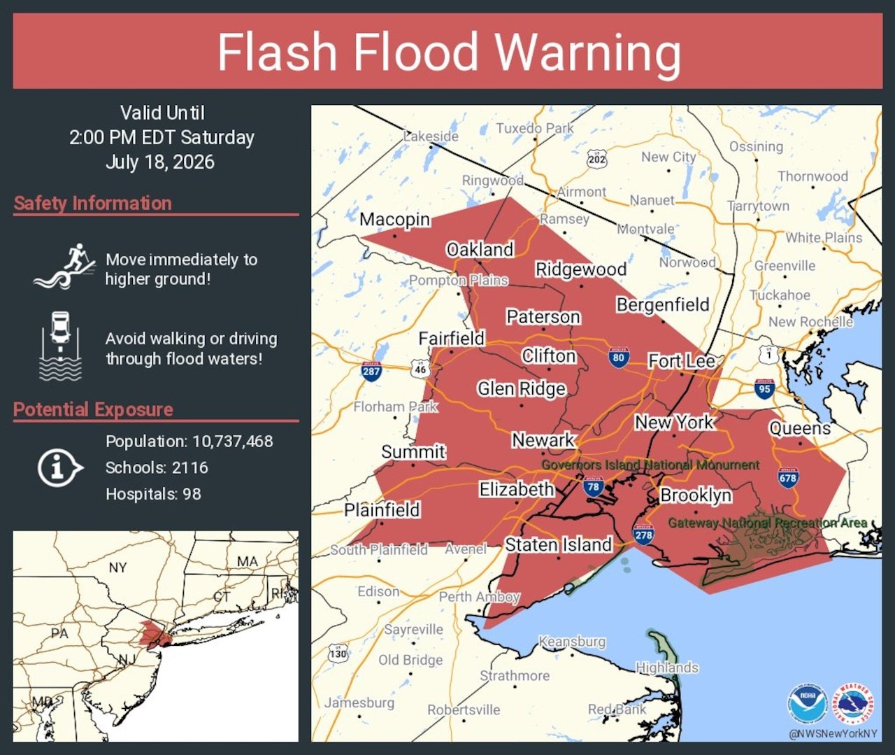
The National Weather Service issued a flash flood warning for Essex, Bergen, Hudson, and Union counties shortly before noon Saturday. Rain in some warned areas was falling at 1 to 2 inches per hour, with other areas seeing rates of 1 to 3 inches per hour, according to the weather service.
A second flash flood warning for Essex, Bergen, Hudson, and Passaic counties followed Saturday evening and remained in effect until 11:30 p.m., targeting areas already hit hard by earlier downpours, according to ABC7 New York. The flash flood watch remained in effect until 2 a.m. Sunday, July 19.
Water rescues, road closures across the region
In Newark, five cars were trapped in water at the intersection of Frelinghuysen Avenue and McClellan Avenue shortly before noon Saturday, according to NJ.com. Police and firefighters safely rescued all drivers and passengers. No injuries were reported.
Flash flooding forced the closure of both sides of Route 440 in Jersey City around 1 p.m. and shut down all lanes of Interstate 287 north of Exit 14 in Bridgewater by 1:30 p.m., according to the state transportation department.
No flooding, road closures, or water rescues within Millburn or Short Hills had been confirmed as of Saturday afternoon.
Tornado watch, enhanced risk
A tornado watch was in effect for much of New Jersey on Saturday before expiring Saturday evening. The NWS Storm Prediction Center rated the day's severe weather threat at Enhanced Risk, level 3 of 5, with primary threats of damaging winds and tornadoes up to EF2 strength, according to the Storm Prediction Center's outlook.
Air quality and safety guidance
The OEM reported air quality at unhealthy levels Saturday morning, with AQI values above 200 expected late morning to early afternoon before improving as the storm system moved through.
Residents can sign up for Millburn Alert through Everbridge to receive emergency notifications and should report power outages to JCP&L at 1-800-544-4877.
- Millburn Police non-emergency: 973-564-7001
- Millburn Fire non-emergency: 973-564-7035
- Millburn OEM non-emergency: 973-564-1970